


rando de la remeize

bpc
User
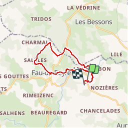

Length
12.7 km

Max alt
1179 m

Uphill gradient
349 m
Km-Effort
17.3 km

Min alt
1007 m

Downhill gradient
316 m
Boucle
No
Creation date :
2015-08-19 00:00:00.0
Updated on :
2015-08-19 00:00:00.0
3h09
Difficulty : Medium

FREE GPS app for hiking
 SityTrail
IGN / Geographical institutes
SityTrail Plus
The world is yours!
About
Trail Walking of 12.7 km to be discovered at Occitania, Lozère, Peyre en Aubrac. This trail is proposed by bpc.
Positioning
Country:
France
Region :
Occitania
Department/Province :
Lozère
Municipality :
Peyre en Aubrac
Location:
Fau-de-Peyre
Start:(Dec)
Start:(UTM)
519611 ; 4954623 (31T) N.
Comments